Bhairab Kunda Trek Guide: Route, Permits & Best Time
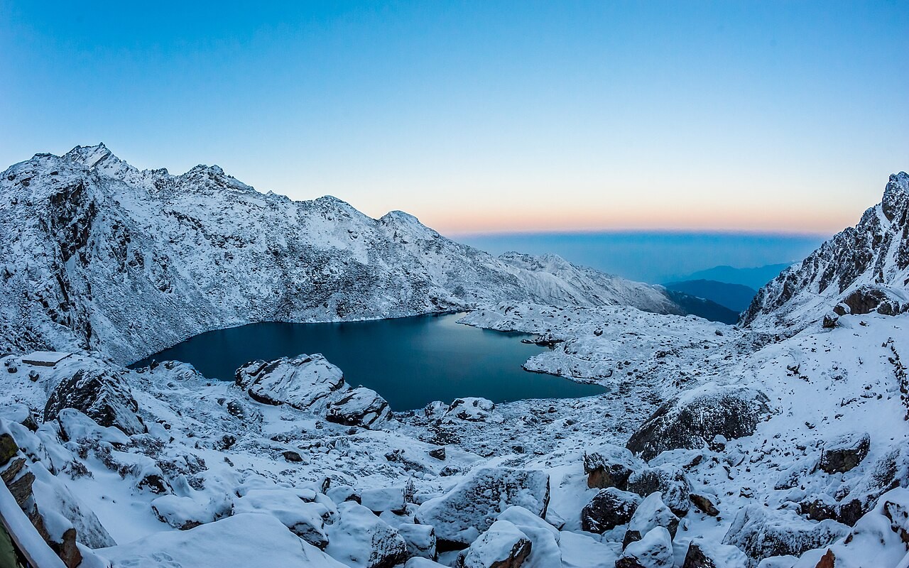
Most trekkers passing through Sindhupalchok are heading somewhere else. Panch Pokhari, maybe, or further north toward the Jugal Himal. Bhairab Kunda sits off to the side of that main stream, and most people who know about it prefer that it stays that way.
At around 4,110m in the northeast corner of Sindhupalchok district, Bhairab Kunda is a cluster of alpine lakes tucked below a ridge that looks out over the Rolwaling, Langtang, and Jugal ranges. The lakes take their name from Bhairab, one of the most powerful manifestations of Lord Shiva in the Hindu pantheon. For Tamang communities in the area, the same lakes go by a different name: Ama Chhemen, meaning Mother's Pond. One site, two completely distinct spiritual traditions, both arriving at the same water.
It is not a heavily trekked route. There are no tea houses above the lower villages. The upper trail is unmarked in sections. You will almost certainly need a local guide, and you should bring a tent. If none of that puts you off, the trek is four to five days of some of the quietest mountain country within reach of Kathmandu.
The religious heart of the trek
Bhairab Kunda has been drawing Hindu and Buddhist devotees long before trekking companies put it in a brochure. The lake's association with Bhairab, the fierce aspect of Shiva who governs time, death, and transformation, is why Hindu worshippers come. Bathing in the waters during an auspicious period is believed to cleanse accumulated sins.
During Janai Purnima, the full moon of Shrawan (typically falling in late July or August), the lake transforms completely. Hundreds of pilgrims make the climb, many of them traveling for days from their home districts. But what sets Bhairab Kunda apart from the better-known pilgrimage at Gosainkunda is the Jhankri presence. Dozens of Jhankris, the traditional shaman-healers of Nepal, converge here specifically because this is one of the few sites where junior Jhankris receive formal graduation from their elders. They drum through the night, perform rituals at the lake's edge, and call on mountain deities in ceremonies that have nothing to do with the tourism economy. If you are at Bhairab Kunda during Janai Purnima, you are watching something that continues whether outsiders show up or not.
Buddhist pilgrims also visit, particularly from Tamang and Sherpa communities. Prayer flags and mani walls circle the lake. Sadhus and Tibetan lamas both use the area for retreat. Prayer flags, mani walls, and votive offerings from different communities sit around the water, none of it cleared away or tidied for outside visitors.
Two ways to reach the lakes
From the Chautara side (most common): The more established approach starts from Chautara, a small hill town in Sindhupalchok that sits roughly four hours from Kathmandu along the Araniko Highway corridor. From Chautara, the trail descends and then climbs through a series of Tamang villages before entering the rhododendron belt. Elevation builds steadily through forests that thin into open kharkas (high pastures) before the final push to the lakes. This approach suits a five-day itinerary well.
From the Melamchi/Helambu side: The western approach comes in from Melamchi Pul Bazaar, connecting through the Helambu network of trails. Longer, typically seven to nine days of walking from Melamchi, but it passes through denser village country and gives better acclimatization time before the high section. It also links Bhairab Kunda into a longer loop that can include Panch Pokhari.
Both approaches share the same upper section from the Sindhupalchok side, converging near the high camp before the lake.
A typical 4-5 day itinerary (Chautara approach)
- Day 1: Kathmandu to Chautara or Jalbire by jeep (4-5 hours). Overnight at a guesthouse in town.
- Day 2: Trek from the trailhead village through lower forests to the first overnight camp, approximately 2,000-2,200m. Five to six hours walking.
- Day 3: Climb through rhododendron and pine forest to a high forest camp, around 3,100-3,200m. Four to five hours.
- Day 4: Final ascent to Bhairab Kunda (approx. 4,110m). The trail above treeline is rocky and exposed, with sections that are faint or unmarked. Three to five hours depending on conditions. Camp at or near the lakes.
- Day 5: Descend to the trailhead and drive back to Kathmandu.
A sixth day builds in buffer for weather or acclimatization. The altitude gain on day four is steep relative to the previous night's camp. Altitude sickness is not rare on this section, and anyone with a history of sensitivity at elevation should plan for an extra day at the forest camp before continuing up.
What the trail is like above the villages
Below around 3,000m, the paths are well-used and generally clear. You pass through Tamang villages where the trail functions as a daily walking route for local people. Tea and basic meals are available here.
Above the last village, the character of the trail changes. Forest gives way to open meadow, then to a rocky high-altitude terrain that looks across into Tibet on clear days. This upper section is where navigation gets difficult. The path that is obvious lower down becomes a series of herder tracks that diverge and converge without markers. A local guide is not optional here. It is the difference between reaching the lake and spending several hours on the wrong ridge.
The lakes sit in a natural bowl below the main ridge. A small shrine stands at the water's edge. The surrounding terrain is bare stone and sky, the distant white line of the Himalayan ranges visible from the camp on clear mornings. After the monsoon clears in September and October, the reflection of the peaks in the still water requires specific conditions: no wind, early morning, clear sky. Most trekkers arrive once. Some of them catch it.
Permits
- Gaurishankar Conservation Area permit: NPR 3,000 (foreigners) / NPR 1,000 (SAARC nationals) / NPR 100 (Nepali citizens)
- TIMS card: USD 20 for independent trekkers / USD 10 with a registered agency
- No restricted area permit required
Permits can be purchased at the conservation area entry checkpoint or arranged through your trekking company in Kathmandu before you leave.
Best time to go
April to June: The spring window. Rhododendrons are in flower on the lower slopes, temperatures are manageable, and the trails are drying out from winter. Views can be hazy in May as the pre-monsoon builds.
September to November: The cleaner season. The monsoon has washed the air clear, the light is sharp, and high camps are cold but accessible. October is the most popular trekking month in Nepal, and even Bhairab Kunda will feel slightly less empty than usual.
July to August: Pilgrimage season, anchored by Janai Purnima. The monsoon is active, which means wet trails, leeches below 3,000m, and cloud cover on most days. But if witnessing the festival at the lake is the reason you are going, you go in monsoon. There is no other time to see it.
December to March: Not recommended. The upper section above 3,500m can be snowbound, and approach roads become treacherous after heavy rainfall.
Practical logistics
Getting there: Buses from Kathmandu's Ratna Park bus park run to Chautara (roughly four hours) and Melamchi Pul Bazaar (about three hours). A private jeep is faster and considerably more comfortable on the rough sections. From Jalbire on the Araniko Highway, the road to some trailhead villages requires 4WD, particularly after rain.
Guides and porters: A guide with local knowledge is strongly recommended for the upper section. Porter rates run around NPR 2,500-3,000 per day in this area. For a five-day trek, most groups carry camping gear for two nights above the last village. A crew based in Chautara or the local villages will know both the standard route and its variations.
Accommodation and camping: Guesthouses are available in Chautara, Jalbire, and the larger villages on the lower trail. Above roughly 2,500m on the Chautara approach, accommodation is limited or nonexistent. The camp at the lakes is camping only. Bring a sleeping bag rated to at least -10C.
Food: Your guide or cook will handle meals at camp. Dal bhat and noodle dishes are available in the lower villages. Above those, carry your own snacks and supplementary food. The altitude reduces appetite, and many trekkers eat considerably less than expected on the high section.
Who this trek is for
Bhairab Kunda is accessible enough for a reasonably fit beginner, but remote enough to require genuine preparation. The altitude is serious, the upper trail has no signage, and the camping is basic. Anyone expecting the infrastructure of the Everest Base Camp route or the Annapurna Circuit will find something quite different.
What the trek offers is quiet. Even in peak autumn season, you are unlikely to encounter many other trekking groups above the lower villages. The cultural life of the place is still functioning as a living thing rather than a backdrop. The pilgrimage continues whether trekkers show up or not.
For Hindu pilgrims, the logic is direct: Bhairab Kunda is a site of genuine spiritual power, and the journey is the practice. For trekkers, it is a chance to walk somewhere that has not been reconfigured for an outside audience.
Both groups end up at the same lake.

-
PO Box: 10987
Thamel, Kathmandu -
+977-01-4700563, +977-01-4700066
Whatsapp: +977 9851167070

